Feast in the East IX
The excitement was palpable in anticipation of my first formal rally in 25 years. With several Iron Butt self directed long distance rides under my belt, I felt like I had the planning and stop management under control and could put in a respectable showing at the 2003 FitE mini-rally.
The planning got started late because I was on a Florida trip when the bonus point locations (BPL) were posted. On my return from Florida Monday evening I loaded in the BPL lat/long to my mapping software and began planning the route.
I was sure those "high dollar" locations in the west would be on everyone’s first plan, just as it was mine. After giving them a once over I quickly rejected that kind of a route. I felt like the distance was just barely doable and having ridden that area knew that traffic could be problematic. Another criteria based on experience was to avoid the Blue Ridge Parkway. The "leaf peeper" season was just coming into full bloom and, again, the risk of traffic was great. In my mind, this was the major variable in planning an aggressive route. If the plan was to average 45mph on the backroads and traffic pushed that down to 35mph then having a million points doesn’t do you a bit of good if you miss the deadline.
The route I decided on was based on garnering bonus points for National Park stamps, I felt like a respectable showing on some BPLs plus catching the maximum park bonus might just put me in a high ranking. It was aggressive but left one safe breakout point in case I was behind schedule.
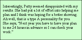
My wife, Patty, was instrumental in helping with the planning process. She contacted the visitor’s centers at my targeted stops and verified the operating hours and locations. First on my list was to get a West Virginia National Park stamp, it would kill several birds with one stone; the FitE bonus for the park, a WV gas stop, and another state on my goal of earning the Iron Butt Association National Parks Tour Master Traveler Award.
With a potential route of around 44,000 points loaded into the GPS I headed to Statesville late Friday afternoon.
Arriving at the FitE home base I began the registration process and here’s where I learned what these rallies are really about, the people! There was an older lady hanging around the registration desk asking about what National Parks were nearby. I thought she was just a bystander. I asked if she rode a motorcycle and the other riders in the room just guffawed. They said "Ride a bike, you ask! You should be asking for this lady’s autograph!" As it turns out I was talking to Ardys Kellerman who has completed 4 of the last 5 Iron Butt Rallies (1993, 1997, 1999, 2001) all after age 60. Wow! I was in awe. I didn’t get her autograph but did catch a nice picture of her. 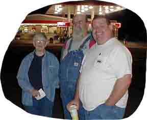 As it turns out there were several IB Rally participants at FitE and chatting with these people was what made the rally the most fun. Especially, Leon Begeman who finished 12th in the 2003 IB Rally on a Kawasaki 250 Ninja. Most impressive was that during the rally he completed 10/10ths, 10 consecutive 1000 mile days.
Finally, after too much time spent "cob rolling" with my fellow riders, Ernie Bose (my riding compatriot from work)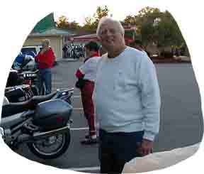 and I got some dinner and retired to his room to finalize the plan and load the waypoints into his GPS. At 11:30 PM I finally get to bed but am too excited to sleep well. Am also worried about hearing the wakeup call. I am hearing impaired and those cheap phones in the motels just don’t cut it—gotta get a Screamin’ Meanie.
At five AM I meet up with Earnie at the rider’s briefing. We saddle up, get our official departure time on our rally books, and head to the odometer check point for our first bonus. By 6:30 AM we’re Northbound on I-77 heading for West Virginia and the first National Park. Not too long after the plan begins to fall apart.
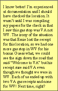
My plan was to get gas in 3 states (NC, VA, and WV) for the bonus points, so I didn’t fill up before we left (first error). We ended up having to stop for gas in NC because neither of us could make WV. To compound the issue we didn’t fill up, thinking that we would be buying gas at least two more times (second error). At least we did buy the Cheerwine for one of the wildcard bonuses. So far, I’m not worried. It looks like we will be getting to the park visitor center before they open at 9:00 AM.
The "Welcome to West Virginia" sign appears ahead and I start thinking about that WV gas bonus (or at least I sure thought it said WV). We pull off at the next stop for fuel. I note that we are at Max Meadows a location of a National Forest Service office, too bad it is 8:00 AM and they don’t open til 9:00. SEE SIDEBAR
We head on up the road, blissfully unaware of the mistake just made and the ones looming ahead of us. I’m looking for the exit and my detail map is missing for this county. Since Ernie has a newer GPS with autorouting, he takes the lead for the next exit. We turn off and he leads the way down a small, narrow, and winding road (read slow). My GPS says we are going due south when we should be going north and I can’t pinpoint our location on the printout of the maps I’d made.
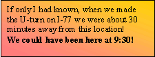
I demand that we stop and go back to the exit, convinced that we have departed the interstate too soon. After we head back northbound on I-77 I get the brilliant idea to read the directions on the back side of the map, pulling it out I see that we had exited at the correct location (mile 14) and we were now passing mile 20. I flag Ernie down, admit my grievous error and we look for the next exit—34! We decide to make an illegal U at the next opportunity (about 3 miles on).
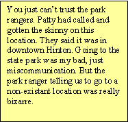
Finally we get back to exit 14, I get my wits about our location and we end up northbound on WV20. This is a beautiful road and it would have been much more enjoyable had it not been so late, it’s now after 9:00 AM and we still have a ways to go. My waypoint approaches, the Bluestone State Park. We turn in and find that the office is about 5 miles down a twisty little road through the park. The time pressure is on and again a wonderful bike road is marginally enjoyed. I had thought it was strange that a National Park visitors center was located in a state park office but I had plugged in the info from Patty, or at least I thought I had. The kid in the office called his boss and we found out that the visitors center was in Hinton, another 7 miles up the road. Directions in hand we head to Hinton where a festival is going on. Since the main road is blocked we park and walk to the location on the map—sure doesn’t look like a visitors center to me, man am I a good judge of location. This is the Railroad Museum, it used to be the visitors center until it moved to Sandstone, 7 more miles up the road. SEE SIDEBAR
At this point, about 10:00 AM, I’m about to give up on the rally. One thing is for sure though, I’m darn well gonna get that WV National Park! Ernie is leading and we cross the New River and take off on River Road, in short order it turns to single lane. I keep trying to flag down Ernie and tell him that there won’t be a National Park visitor’s center on a single lane road. Of course, I have zoomed in on the GPS (back in a county now that I have loaded) and see that we are paralleling 20 on the east side of the river, we’re on podunk road on the east side. Bridges don’t come cheap and I just can’t see a positive outcome to staying on this road.
We pass Sandstone Falls and it is beautiful. The rapidly flowing water cascades over the boulders and splashes some twenty feet below to raise a fog across the 200 yard span of the river. The scenery is great, the road is fun, and the clock is ticking.
Ernie finally stops in another 3 miles or so when the road turns to gravel. We reconnoiter the situation and realize that there is no alternative but to retrace our route, go back through Hinton (festival and all) and get on 20.
Well the tour of both sides of the New River was worth it. River Road on the west side is almost at water level. For a remote area this road is well populated. There are fishing camps, houses, and trailers all along the river and I can understand why, this is about as scenic of a river valley as I have ever witnessed. WV20 on the east side of the river is up on the river bluff, at times perhaps 500 feet above the river. The views here are completely different, looking down on Sandstone Falls was not as impressive as almost being in them.
Finally, the Sandstone Visitors Center sign appears. The location? Just north of I-64 at exit 139! The time? Right at 11:00 AM. SEE SIDEBAR
The rally? Well, Ernie and I mull it over and decide we will take the BPLs one at a time, letting his GPS reroute us accordingly. I know I have screwed the pooch and we won’t get a decent score. I quit worrying about the rally and decided to enjoy the ride realizing that I had already met several of my objectives: have fun, find interesting roads, and see the countryside (getting the WV National Park Stamp improved my spirits too that was state number 19 out of 25 needed).
We made the following BPLs, at each deciding what the next would be (thank goodness Ernie had a GPS that would autoroute, I would have just headed back to the barn):
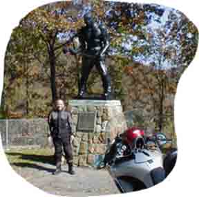
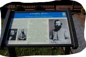
- 49 Big Bend Tunnel – 5433 points (pic of me and Big John Henry)
- 46 Willeville Bike Camp – 2054 points
- 41 Laurel Hill – 2355 points
We managed to pick up all the wildcard bonuses and the beverage bonus for a grand total of 37,693 points putting Ernie and I in a tie for 34th out of a field of 42. Not great but we didn’t get time barred :-) SEE SIDEBAR
Even though the plan fell apart early on, I had a great day, I had met all my goals and one I didn’t even plan. The biggest bonus of all was the socialization with fellow long distance riders.
Lessons Learned
- Plan a more aggressive schedule. My average speed on the backroads and byways was higher than anticipated. Could have made the long routes I’d thought about.
- Fill up the gas tank before you start and at every stop. You only need a record of the date, time, location. The value of the receipt is meaningless.
- Verify locations for planned stops and get directions.
- As always, stop time management is crucial. As one rider said at the rally, "You can increase your speed 1mph for 3 hours or cut 3 minutes off of a stop.So many guys run triple digit speeds when all they have to do is manage their stop time better."
Looking forward to being at FitE X. Hmmm, the Palmetto Ramble and the MD20/20 are between now and then, see you there :-)
Pictures from FitE IX